The Causeway
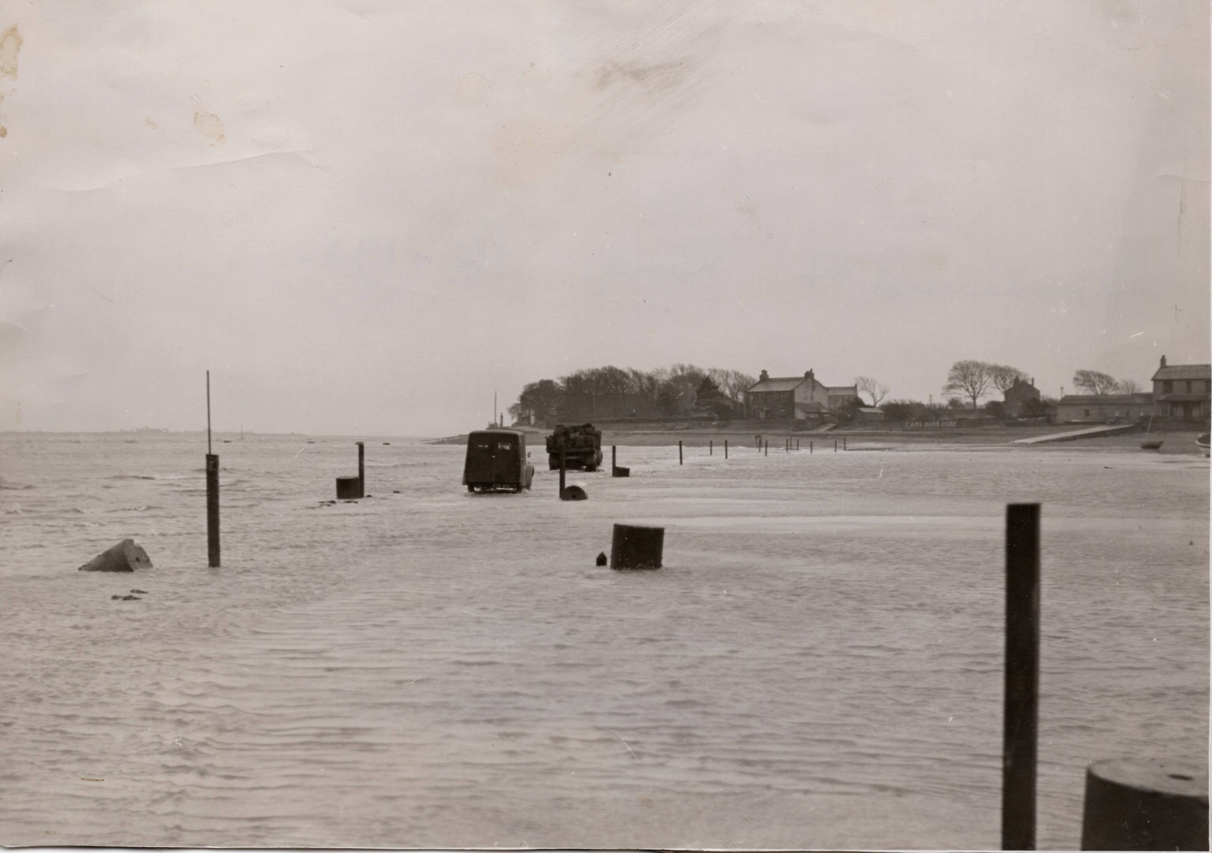
Between Overton and Sunderland Point lies the tidal causeway, it is a mile and a quarter in length stretching from the cattle grid and the hump over the flood banking in Overton to the gravel foreshore at the Point. Depending on the tide height and weather conditions, large sections of the road disappear under the sea - twice a day - most days of the year. The village is the only UK community on the mainland where the only vehicle access is via a road frequently covered by the tide. (Photograph above from the collection of Hugh Cunliffe)
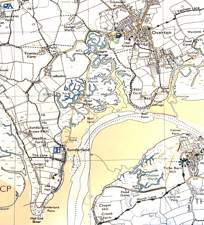
Ordnance Survey Map 296 crown copyright. Permission Ordnance Survey
The ordnance map above charts the route of the road through ‘Lades Marsh’ a salt marsh of mixed vegetation thriving on the mineral rich sediments carried by the tide into the Lune estuary from Morecambe Bay. Although it appears a fixed topography, it is a dynamic environment which has seen considerable growth and spread for more than a century but is now in gradual retreat.
Interwoven with other vegetation on the marsh is spartina angelica. A tough, vigorous species of grass which is a recent arrival in the Lune Estuary. It is mainly planted deliberately to stabilise deposits of sand, mud, and silt but has appeared here by chance and has become established in a continuous sward. It is encouraging fresh platforms for growth and the continuous vertical build-up of the marsh.
In May the marsh is awash with a haze of pink. Sea-Pink (also known as Thrift) is a small low growing plant which provides a wonderful display for a few weeks each year.
Sunderland Point is famed for its variety of birdlife. Crossing the causeway provides an excellent opportunity of spotting species such Little Egrets, Oystercatchers, Red Shank, Curlew, Lapwing and Shelduck. During the spring and summer cattle will be grazing on the marsh, sometimes they amble off the marsh onto the causeway and become unwelcome visitors in the village.
The road traverses the marsh twisting and bending between the gullies and mudbanks, there are two bridges; Lades Bridge near Overton and Wood Bridge close to Sunderland Point and numerous culverts allowing a bypass for the sea.

Gerard Bagot (left) and Bert Smith at Lades Bridge circa 1935: From the collection of Alan Smith

In many places the road appears to cut though the salt marsh where it has grown higher than the road. This has created the perfect conditions for the entrapment of waterborne silts and mud.
Driving conditions can be treacherous not only the dangers of a rising tide but from the slippery and salt laden muddy surface.
The surface of the road midway between the Point and Overton: Image from the collection of Bill Morris

Without the constant movement of traffic dispersing the sediments, sections of the causeway would become impassable.
For the last 200 years it has been a challenging task for civil engineers to keep the road passable. A training wall was built in the centre channel of the River Lune in the 1850s and expanded in the 1890s. Its purpose was to ‘train’ the main flow of the river to keep it to the same route. However, this also accounts for the build-up of material from the sea which has caused the rapid expansion of the marsh. Compared with our OS map above, this map of the 1840s shows mainly mudflats without vegetation.
Ordnance Survey Lancashire XXX1V Published 1848: Permission National Library of Scotland.
And passable the road must be. It is the lifeline into the village, its the access route for the emergency services, health care visitors, refuse collections, Royal Mail, and the maintenance of utilities.
There is no public transport beyond Overton so visitors to Sunderland Point via the road must use their own transport if not walking. It is the same for residents - and their children - who for many generations, until a taxi service began in the late 1970s would walk the road to and from the school in Overton.

Image from the collection of Wilton Atkinson
This charming hand coloured postcard from the 1930s has the children of the Point returning home over a muddy road.
As well as many minor repairs and mud removal, every 50 years or so major works have been required to lift sections of the road to the new level of the salt marsh.
The photograph below shows the exceptionally thick covering of mud on the road before the 1930s upgrade.

The causeway in the 1920s: From the collection of Hugh Cunliffe
The origin of the road is unknown, but it is believed to follow the same route from inception. In 1824 a report appeared in the Lancaster Gazette of ‘improvements in the Sunderland Road by rebuilding and widening the bridges’. In 1880 the causeway was resurfaced in stone.

The road in the 1920’s, just a stony surface: Image from the collection of Hugh Cunliffe.

In the Lancaster Gazette of 1890, we see the first public petition for a new, tide free road. In 1934 into 1935 there was further agitation and fresh petition for a new road. Whilst not granted, the causeway road was raised again and given a tarmacked surface in the late 1930s.
The last major improvement occurred in 1978 after a decade of debate over a new or raised road. Eventually, the road was raised considerably eliminating a dip close by Wood Bridge and lifting the section closest to the Point.
Today, there is no interest in a new road - even if the enormous cost could be found and the remote chance of planning permission overcome - however, it is again in a worn and muddy condition requiring extensive improvement. Despite the challenges of the causeway, it is a magical route through the marsh and residents and visitors alike know they are entering a special place.
Photograph from the collection of Andy Biggs
Click on button to return to the environment home page
Or, to enter the next page ‘Flooding’ click here