The Tithe Map of 1844
A snapshot in time
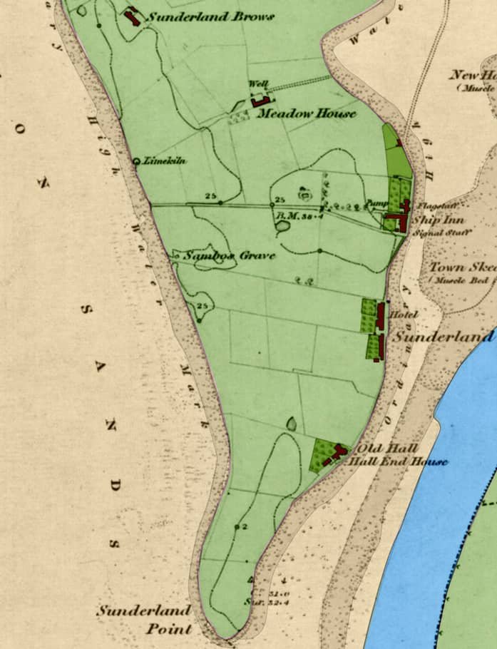
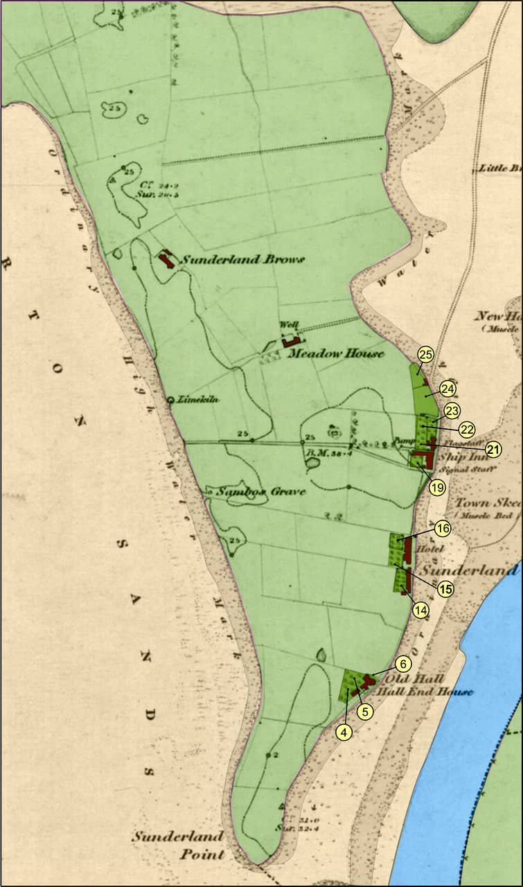
Sunderland Point in the 1840s: OS map courtesy National Library of Scotland. Colouring Paul Hatton.
In his book ‘The Story of Sunderland Point,’ Hugh Cunliffe includes a summary of land ownership in 1844 and a hand-drawn map showing the owners and occupiers on a double page.
Following Hugh, we obtained permission from the Lancashire Archives to examine closely and publish photographs of the 1844 Tithe Map and the accompanying Tithe Schedule.
This is of great interest as it offers a detailed snapshot of land ownership by field (and garden) at Sunderland Point in the mid-19th century and an insight into economic and social relationships.
Only Jenny Edmundson at the Old Hall (number 21) was probably a full-time resident who owned her property. All other residents, including those at the farms and Inns, were tenants.
Also, and unusually, Jenny and three other women were four of the ten who owned property at the Point. The four were all unmarried. It would not be until the 1880s that married women could fully own property in their own name.
The Point remains a favourite destination for Lancaster families during the summer, but its heyday as the seaside spa “Little Brighton by the Sea " is over. At the time of the 1841 census, of the 29 homes, only 16 are in full-year occupancy. There were fifty-four full-time residents, and the livelihoods were almost all fishing and farming. The tenants of ‘The Hotel’ and the ‘Ship Inn’ are also farmers. Perhaps as many as six of the homes were occupied by members of the Dickinson Family.
Images from the original Map
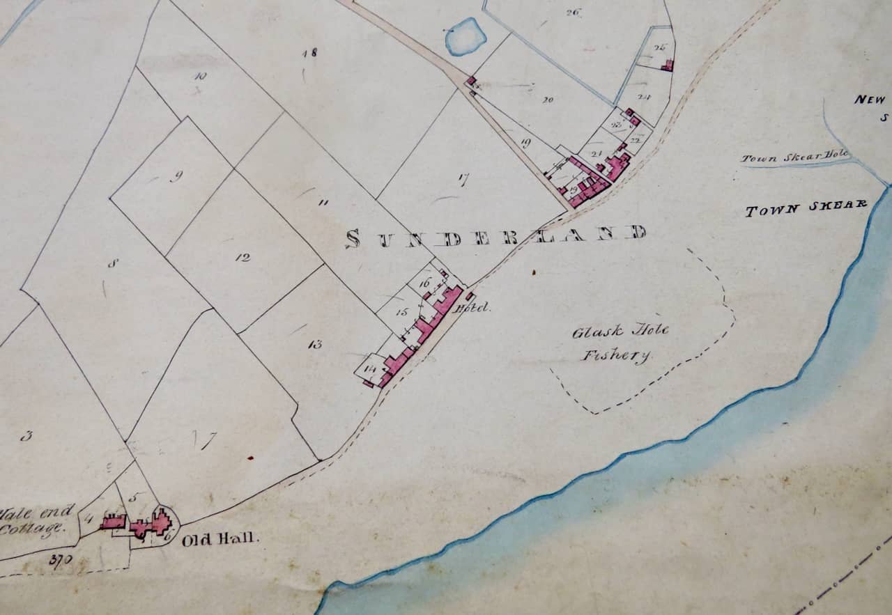
Hall End, Second Terrace and First Terrace. Source PR 326/3/8. Published with permission from Lancashire Archives and Local History, Lancashire County Council: Photo Kate Hurst
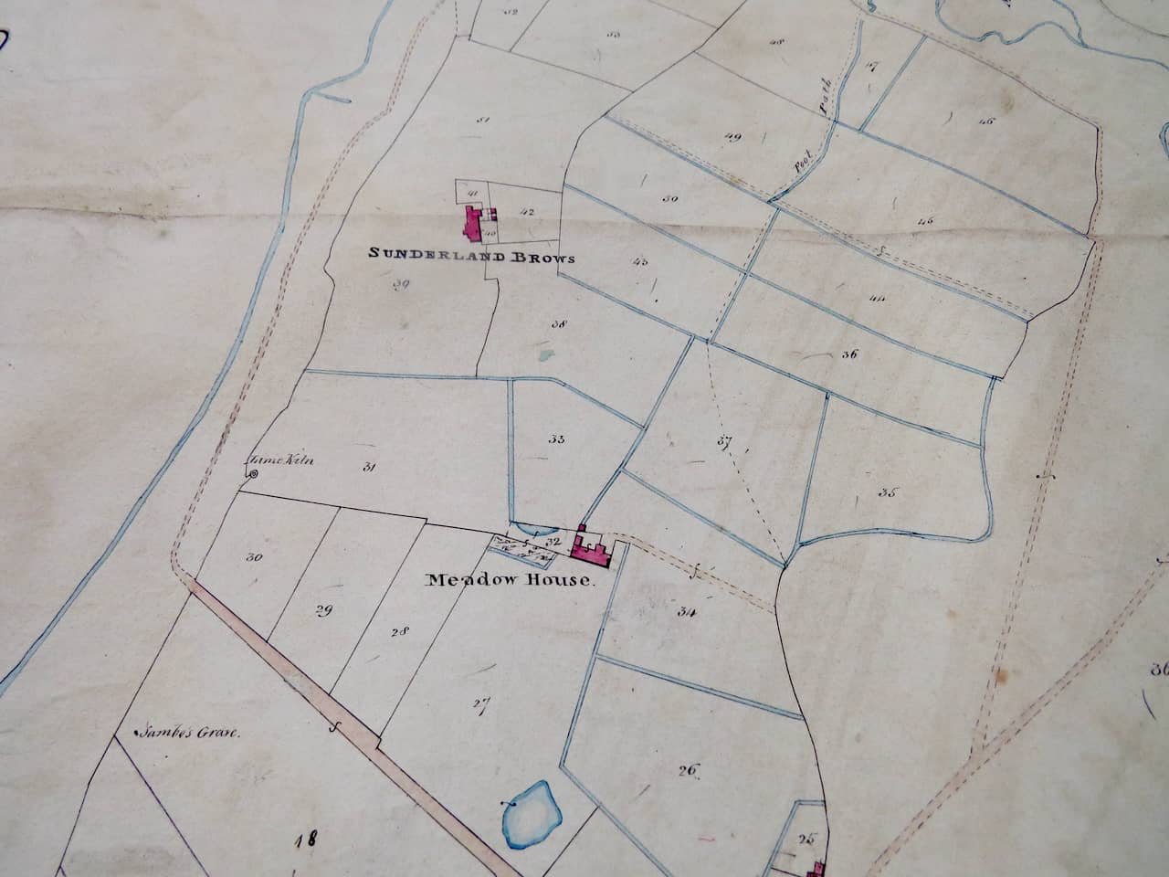
Sunderland Brows and Meadow House Farms: Source PR 326/3/8. Published with permission from Lancashire Archives and Local History, Lancashire County Council: Photo Kate Hurst
The Tithe Act of 1836
Tithes were an ancient payment system in which one-tenth of the land’s produce (crops, eggs, cattle, timber, and fish) was given to the parish rector as alms and remuneration for his services. The tithes were often stored in a tithe barn connected to the parish.
The legislation substituted the traditional payment for monetary payments. The Act became well-known for the tithe maps necessary for its mandated valuation process.
An apportionment schedule that listed each map item by number was associated with each map. Each entry included details about the owner, tenant, area, name or description, state of cultivation, rent charge payable, and tithe owner.
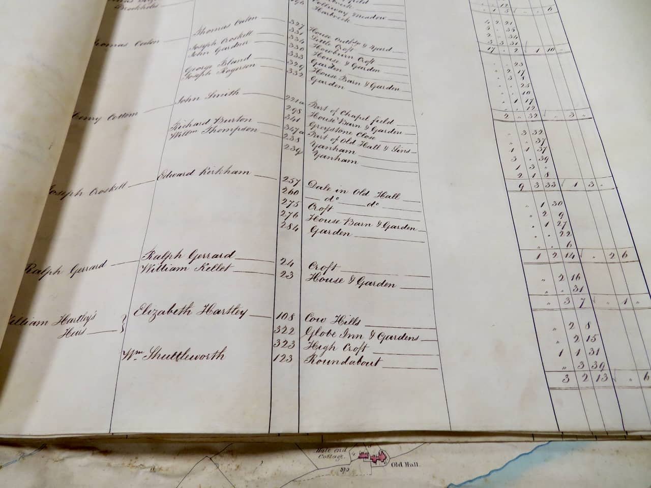
Extract of a Tithe Schedule: Source PR 326/3/8. Published with permission from Lancashire Archives and Local History, Lancashire County Council: Photo Kate Hurst
To show the details of the Tithe Survey map, we have superimposed the reference numbers used by the Tithe Commissioners to identify the fields and gardens at Sunderland Point onto the 1840s Ordnance Survey (OS) Map.
The OS was already involved in systematically mapping Britain for military and administrative purposes, producing highly accurate maps. The OS supplied the foundational geographic framework upon which tithe maps often depended. At Sunderland Point, the result is almost exact.
The Tithe Map
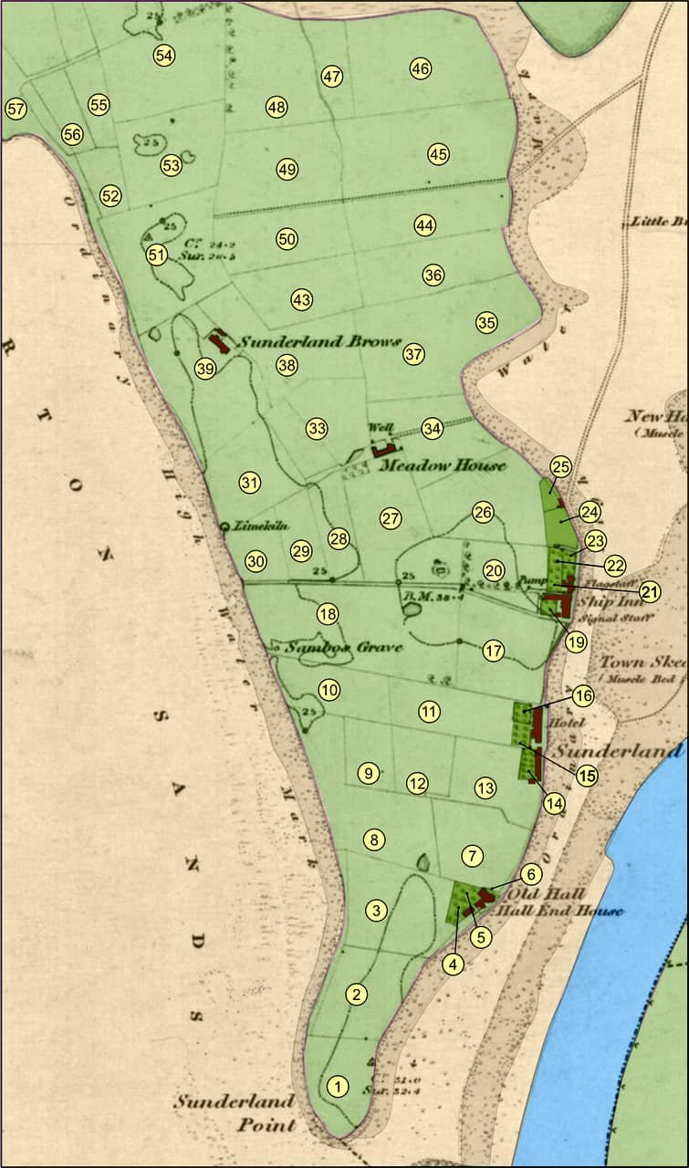
Tithe Schedule field and garden identification numbers: OS map courtesy National Library of Scotland
Looking through the tithe schedule, it is possible to group the separate fields, which reveals the farms, the owners, and the tenants.
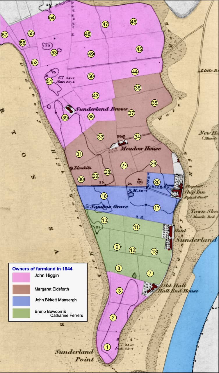
The owners of Farmland: OS map courtesy National Library of Scotland
The Farm Landowners and tenants
- And a quick who’s who.
John Higgin: Sunderland Brows and Hall End Fields (86 acres).
A well-known Lancaster family of solicitors with several properties elsewhere, including Overton. John Higgin (senior) bought the Brows farm from Thomas Hinde in 1811 and added the Hall End fields in 1825, acquired from John Stout Esq. Towards the end of his life, John passed it to his son, John Higgin.
John (senior) was born in 1761 and served as the Governor of Lancaster Castle and Town Clerk of the Borough Council of Lancaster from 1824 to 1836. His son, John, born in 1785, described himself as a solicitor when he married Susannah Armstrong in 1814.
Both men died in 1847. John Senior in January at the age of 86, and his son in October at the age of 62.
Here is the sale notice placed in the Lancaster Gazette in 1848. The Sunderland Brows farm became the property of Henry Hargreaves. Peter Constable Maxwell (more later) acquired Hall End fields.
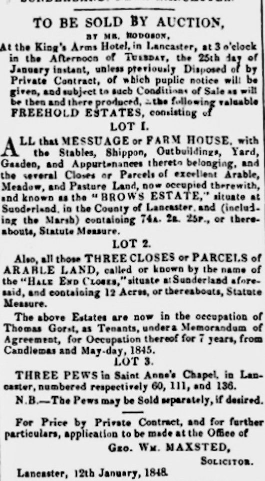
Courtesy Guardian Newspapers
Margaret Eidsforth: Meadow House Farm (78 acres)
Hugh tells us that the Eidsforth family was a long-established family in Poulton who owned considerable amounts of land in the locality. A memory of them remains with Eidsforth Road andTerrace in modern Morecambe.
Margaret, born in June 1804, was the daughter of Anthony and Sally Eidsforth. As Margaret had never married, she held the property in her own right.
Her father, Anthony, inherited considerable property, including Poulton Hall, from his uncle Anthony Helm in 1799. Like John Higgin above, Anthony Helm was once Governor of Lancaster Castle.
Anthony died in 1840, and in an unusual will, he divided his property among his seven children. The restrictive provisions required each sibling to sell to one another before a sale to a third party. It seems Anthony intended that the two sons, Thomas first and then John, would eventually own all the property. However, the sons and daughters ceded their rights to Margaret, which allowed her to sell the entire estate.
In 1848, the properties were divided into 30 lots and sold at the Kings Arms in Lancaster.
However, Margaret seems to own Meadow House farm in her own right, which she attempted to sell (without success) in 1841, as this edited version of the notice shows.
Lancaster Gazette 31st July 1841
TO BE SOLD BY AUCTION, at the house of Mr Braithwaite, the sign of the Royal Oak, in Lancaster, on Tuesday the 10th day of August 1841. A valuable Freehold Estate called MEADOW HOUSE situate at Sunderland, a delightful bathing place in the Township of Overton, in the parish of Lancaster, on the banks of the River Lune, adjoining the sea shore, on the East and West and distant from Lancaster about six miles. Comprising a convenient Farm House, with Barns, Shippons and Stables and other suitable out buildings, garden, Orchard and 78A.0a.38p statute measure or thereabouts of excellent Arable, Meadow and Pasture land. The estate (except for about 11 acres) is free of Great Tithes and abounds with Marl, Clay and Sand, is pleasantly situate and commands beautiful and extensive views of the Bay of Morecambe and the Lancaster, Cumberland and Westmorland Mountains. A steam packet from Lancaster to Liverpool and back passes Sunderland several times every week. Further information may be had of Miss Eidsforth of Poulton Hall.
Margaret left Poulton Hall and lived in Cable Street in Lancaster, where she died in 1879.
In 1844, Thomas Gorst was the tenant farmer of both Meadow House and Sunderland Brows farms.
Thomas Gorst – tenant farmer
Originally from Goosnargh, a village near Preston. In 1844, he was 38 years old and a well-known farmer. In 1837, he married Margaret Hargreaves, the niece of Henry Hargreaves, who would later occupy and own Sunderland Brows Farm.
After the sale of the two farms, the 1851 census shows Thomas and Margaret living in Overton. They moved on to farms in Middleton and eventually to the small 26-acre Daisy Bank Farm, where Thomas died at the age of 83 in 1889.
Bruno Bowdon and Catharine Ferres: Point Farm (23 acres)
Bruno and Catharine, as well as the farmland, also owned all the Second Terrace house properties from number 13 up to and including number 20 Cotton Tree Cottage (excluding 21, 22 and 23). They were absentee owners who may have never visited the Point. They had acquired the property from within their extended family. (A full explanation is provided in Beth’s books)
Very simply, the land and buildings had been acquired by the Willoughby family in the early 1800s. By the mid-1810s, it had come into the ownership of Francis Willougby, a spinster, who used the Big House (where the Reading Room is now located) as a summer residence.
Although planned for sale on her death in 1821, it was acquired within the Ferrers family, who were related by marriage to the Willoughbys. John Peter Bruno Bowdon had married into the Ferres family. The Bowdons and Ferrers were both Midlands families.
Peter Constable Maxwell, who succeeded as the next owner of the property, became connected to the family on his marriage to Helena Bowdon, the daughter of J. P. Bruno Bowdon and Mary Martha Ferres (the niece of Catharine Ferres), I think!
John Kitchen – tenant farmer and innkeeper
John Kitchen is the Tenant farmer and innkeeper of the ‘The Hotel’. He is 63 years old and married with three children. During his lengthy tenancy, the premises are known as ‘Kitchen’s Hotel.’
Before him, the tenancy was briefly held by John Bagot, and before him, it was held for many years by John Gerrard (junior), Ralph's brother, who we will find at the Ship Inn (and elsewhere).
Three years later, John leaves ‘The Hotel’ and Point Farm, as announced in this notice printed in the Lancaster Gazette, January 1847
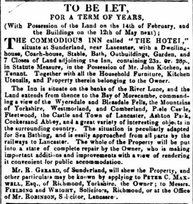
Courtesy Guardian Newspapers
John Birkett Mansergh: Ship Inn Farm (15 acres)

In blue, the Ship Inn farmland: OS map courtesy of the National Library of Scotland
John, born in 1805 in Lancaster, was 39 in 1844. He had recently inherited this property from his uncle, James Birkett. As well as the farmland, it came with the corner properties at the end of First Terrace, numbers 8,9,10, 11 (the Ship Inn) and Upsteps Cottage. Also included was the Summer House at the top of the Lane. His brother Robert inherited Gravel Cottage (number 2).
His uncle, James Birkett, bought the properties in 1812, having previously been owned for many years by George and his father, Richard Jackson. George Jackson is remembered for his friendship with the Rev James Watson, who wrote the Gravesite elegy.
John B. Mansergh is well known as the founder of the Mansergh drapery store in Lancaster. He had a business relationship purchasing linoleum cloth with James Williamson, who would become the owner of Hall End House (number 22) in 1853.
John will be forever remembered (reviled) as the man who ended alcohol licenses in the early 1860s.
The property would remain in John’s ownership until he died in London in 1873. The tenant in 1844 was Ralph Gerrard.
Ralph Gerrard – tenant farmer and innkeeper
Ralph was born in 1787 into a large family at Sunderland Point (perhaps in number 20, where we think his parents lived).
Before moving to the Ship Inn and farm in the early 1840s, Ralph lived in Glasson Dock with his wife, Elizabeth and their four children, where he held the tenancy of the Dalton Arms. His brother John once held the tenancy of ‘The Hotel’, then known by his name as ‘Gerrard’s Hotel’. He has two other brothers living on the Point, Richard and William Gerrard, both fishermen.
Like many other tenants at the Ship Inn, Ralph did not stay long, and by the end of the decade, he had moved to Skerton in Lancaster, where he died in 1853. Ralph was also a property owner on the Point, as we will see later.
The Field Names
The schedule of individual fields should have included agricultural use. Apart from some entries, this is disappointingly missing on the Sunderland Point peninsula. There is mention of meadows and pasture, and interestingly, the three Point End fields were stated as of arable use, but the picture is incomplete.
What we have are the field names as given to the commissioners. They are transcribed onto this map.

The names of fields on the peninsula: OS map courtesy of the National Library of Scotland
The Croft Fields and Gardens
In the following map, we show separately the gardens and croft fields identified on the Tithe Map. Croft fields were small land areas, less than an acre but large enough to grow vegetables and keep some livestock, a cow, perhaps a pig, certainly chickens.
The numbered Gardens and Croft Fields: OS map courtesy of the National Library of Scotland
Owners of the fields and gardens and the tenants
(With photographs from the original map).
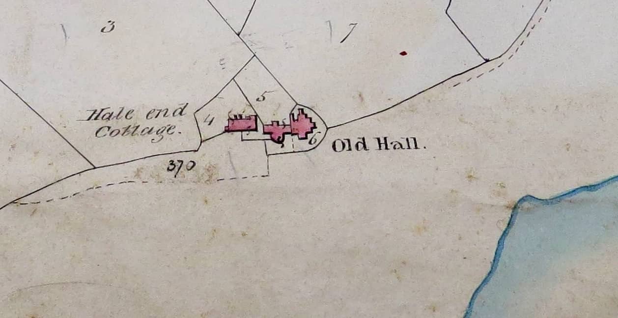
Hall End properties. 4 and 6 are owned by Jenny Edmundson, and number 5, by Ann Hinde. Source PR 326/3/8. Published with permission from Lancashire Archives and Local History, Lancashire County Council: Photo Kate Hurst
4 – Jenny Edmondson and tenant Thomas Cottam
Hall End Cottage and Garden: Jenny Edmundson (living in the Old Hall) bought it from John Higgin 1834. Thomas Cottam, possibly a tenant farmer, had recently moved into the house.
5 – Miss Hinde and herself
Hall End House and Garden: Ann Hinde, born in 1764, was a member of the extensive Hinde family and the granddaughter of Thomas Hinde, who was deeply involved in the slave trade from Lancaster and later Liverpool. She was 80 years old in 1844. Her primary home was in Dalton Square in Lancaster. She purchased the property in 1829 from Mary Wright, and after she died in 1852, it would be sold to Lancaster’s leading industrialist, James Williamson.
6 – Jenny Edmondson and herself
The Old Hall and Garden: Jenny inherited the property from her father in 1834, who had made the original purchase in 1818. It’s not certain, but Jenny seems to have lived permanently here with Margaret Nelson, listed in the census as a servant, and a coachman, John Worthington, before moving to Lancaster for the final years of her life, where she died in 1863.

Second Terrace, all properties owned by Bruno and Catharine with John Kitchen as tenant Source PR 326/3/8. Published with permission from Lancashire Archives and Local History, Lancashire County Council: Photo Kate Hurst
14/15/16/ – Bruno Bowdon and Catharine Ferres with John Kitchen tenant (as described above)
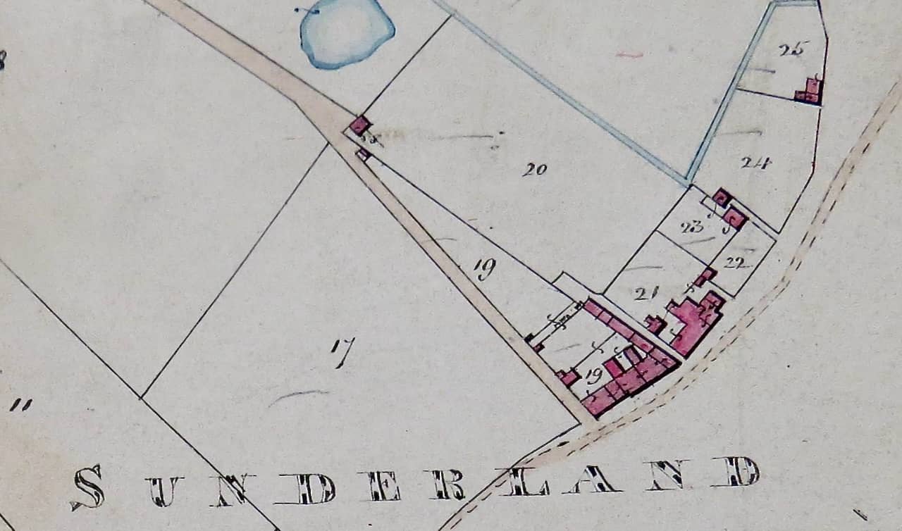
First Terrace, the owners are 19, John B. Mansergh. 21, heirs of Rev JRG Manby. 22, Thomas Wilkinson. 23 and 24 (Croft fields) Ralph Gerrard, 25 Robert Mansergh: Source PR 326/3/8. Published with permission from Lancashire Archives and Local History, Lancashire County Council: Photo Kate Hurst
19 – John Birkett Mansergh and tenant Ralph Gerrard
As described in the Farm fields above.
21 – Reverend John R. G. Manby’s heirs
Number 7 and Garden: The Rev John Ralph George Manby, who had recently died, had been the vicar of Overton. It’s unclear who he bought the house and famous garden from. It may have been 1827 from James Nottage, who grew the giant red cabbage, but possibly from John Gerrard Junior (of ‘Gerrard’s Hotel’). The house and garden were sold by Manby’s heirs to Charles Bower in 1846, who may have spent part of his childhood in what is now 1 Cotton Tree Barn.
22 – Thomas Wilkinson and tenants Barbara Gardner, William Dickinson, Margaret Smith.
Thomas Wilkinson bought the house properties (numbers 4, 5, and 6 today) and garden at auction in 1817. Thomas had lived at the Point but by 1844 had moved to Overton. Of the tenants, William (later known as Barney) Dickinson and Margret Smith were brother and sister. Barbara Gardner, listed in the census as a grocer, had the maiden name of Dickinson, but it is uncertain if she was related. In 1849, Betty Wilkinson, widow of Thomas, sold the three properties and garden to Richard Gerrard.
23 – Ralph Gerrard and William Kellet
Ralph Gerrard, whom we met earlier, owned Old Customs House (3A) and the Croft field. He was also the tenant at the Ship Inn and farm. William Kellet was a fisherman, and his wife Esther was one of the daughters of William and Sarah Curwen at Gravel Cottage.
24 – Ralph Gerrard and himself
Ralph also owned this Croft field, and the Tithe Schedule suggests he ‘farmed’ this land himself.
25 – Robert Mansergh and William Curwen
Gravel Cottage (number 2): Robert, aged 34, is five years younger than his brother, J.B. Mansergh, and has recently inherited the property from his uncle. Robert is listed as a woollen and lined draper in Lancaster. The tenant, William Curwen, was originally a weaver in Overton. He and his wife, Sarah, lived here for many years and had eleven children. Margaret, the eleventh child, married William Townley and, in the 1850s, moved into Hall End Cottage (number 23). Their descendants occupied numerous houses over the following 150 years.

A view of most of the original Tithe Map: Source PR 326/3/8. Published with permission from Lancashire Archives and Local History, Lancashire County Council: Photo Kate Hurst
We are grateful to Beth Hampson for the information from her books and to Ann Hatton for her additional research. Any mistakes are mine and will be corrected when spotted.
We extend our special gratitude to Paul Hatton for the visual presentation of the maps.
Additionally, we thank Kate Hurst for compiling information and photographs from the Lancashire Archives.